

Stratigraphy and Geological Correlation is the only journal in the world designed to provide comprehensive coverage of the fundamental and applied aspects of stratigraphy and the correlation of geological events and processes in time and space. Articles are based on the results of multidisciplinary research, and are directed toward researchers, university professors, students, and geologists interested in understanding stratigraphy and the chronological features of the world's geological record.

Geologists today use Steno’s principles to date layers of sediment and create geologic records of past life forms, depositional environments, climates, human activities, and more.
WHAT IS STRATIGRAPHY?
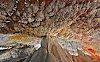
Stratigraphy is a branch of geology concerned with the study of rock layers (strata) and layering (stratification). It is primarily used in the study of sedimentary and layered volcanic rocks. Stratigraphy has two related subfields: lithologic stratigraphy or lithostratigraphy, and biologic stratigraphy or biostratigraphy.
FUNDAMENTAL PRINCIPLES OF STRATIGRAPHY
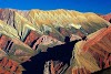
1) Law of Original Horizontality: Beds of sediment deposited in water form as horizontal (or nearly horizontal) layers due to gravitational settling

2) Law of Superposition: In undisturbed strata, the oldest layer lies at the bottom and the youngest layer lies at the top.

3) Law of Lateral Continuity: Horizontal strata extend laterally until they thin to zero thickness (pinch out) at the edge of their basin of deposition

4) Law of Cross-Cutting Relationships: An event that cuts across existing rock is younger than that disturbed rock.

5) Principle of Inclusion: Fragments of rock that are contained (or included) within a host rock are older than the host rock.

IMPORTANT CONCEPTS
Formations
Particular rock units, especially sedimentary rocks, can often be recognized over large areas. The smallest scale rock unit or sedimentary unit that can be mapped is called a formation. The formation is the basic division for identifying and correlating sedimentary strata. A formation may consist almost entirely of one rock type, for example Limestone, or may be composed of multiple Rock types, for example limestone, Shale, and Sandstone, that all formed in one related Environment, such as a coastal environment with rising and falling sea level. Formations can be subdivided into members which are a set of recognizable strata within a formation that are found in only a portion of the areal extent of the formation. The least subdivision of a formation is the bed which is recognized by visual changes in colour, grain size, or composition. Formations vary in thickness from a few meters to a few thousand meters. Beds vary from a few millimetres to a few meters in thickness. In some cases, adjacent formations may be combined into a group of related formations, all having been deposited in similar depositional environments.
changes of sedimentation resulting from changes in sea level
Changing sea level exerts a strong influence on sedimentation. In the coastal environment rising sea level causes a Transgression or shoreward migration of the coastline . The beach moves inland. Clays are deposited on top of sands that were deposited in the former beach and nearshore environment. In warm, clear water, limestone may be deposited on top of shale. A sea level drop causes a regression or oceanward migration of the shoreline. Coarser sediments are deposited on top of fine as water depth decreases. Sea level also affects terrestrial deposition.
correlation.
Correlation trying to fit together sedimentary strata found in different places. Geologists try to determine the relative age of widely separated strata. They are especially interested in determining layers in separate strata that are exactly the same age. This task is complicated as distance increases and sedimentary environments change. One method for correlation is looking for similarity of rock type and characteristics (grain size, composition, cements, sorting and rounding) . Since there are a multitude of similar looking sandstones, for example, more information than that is usually needed. An important tool is to compare the sequence of Beds. As sea level rises and falls, or as the climate changes in a region, all deposited strata will experience the same changes of conditions. All might record a transgression followed by a regression. This sequence allows for confident correlation. Some strata may contain very distinct, unusual layers. These can serve as helpful marker beds . Fossils are very important for doing long distance, even global, correlation of sedimentary strata, especially if the strata contain fossils of organisms that had wide Geographic ranges . Certain Geophysical Methods are also very useful for correlation. Various Electrical methods (see lab) can be used to characterize sedimentary units in a well for which Lithological information is unavailable (oil drillers normally don't core a well and bring up pieces of the strata intact because that is very expensive; it is easier to grind the rock and flush it out).
Alongside Biostratigraphy using fossils, Magnetostratigraphy is extremely important for correlating strata from distant continents and to the standard timescale. Everyone knows that the Earth has a magnetic field. Most rocks contain small amounts of magnetic minerals such as magnetite and hematite. The magnetism in these magnetic mineral grains are permanently aligned with the Earth's magnetic field at the time the rock forms. The Earth's magnetic field has reversed at odd intervals throughout geologic time. Sequences of sedimentary strata record the reversals of the Earth's magnetic field. Since all points on the Earth's surface experience a field reversal at the same time, a particular reversal recorded in sediments on opposite sides of the globe allows an easy exact correlation. Biostratigraphy and magnetostratigraphy are commonly used together to forge the best correlation possible.
unconformities .
Unconformities are Erosional surfaces within a sedimentary sequence. They represent missing time in the rock record. There are three kinds of unconformities. In nonconformities, sedimentary strata lie above plutonic igneous rocks or metamorphic rocks. Since the crystalline rock form at depth in the Earth's crust and sedimentary rocks are deposited at the Earth's surface, erosion must have removed a great thickness of rock from above the crystalline rock before the sediments were deposited. At Angular unconformities, non-parallel sets of sedimentary strata meet. One set of strata (the upper) cuts across the ends of the tilted sedimentary strata. Erosion must have occurred to expose these "ends" because sediments are deposited as continuous, horizontal layers. Disconformities are subtle time gap between parallel sedimentary strata. They may be recognized by recognizing that certain fossils are missing from the expected fossil succession known from other locations, a large-scale hill and valley topography on the unconformity, a basal conglomerate in the unit above the unconformity containing clasts (inclusions) of the unit from below the unconformity, or unrelated strata superimposed, for example sandstone directly above limestone (shale would normally be deposited between these two as sea level fell - Walther's Law .
unconformity-bounded sequences .
Most unconformities are local, resulting from changing sedimentation, local tectonic/structural events, etc. Some, however are global events caused by sea level fall. Major stratigraphic sequences on the continents have resulted from major transgressions that flooded the continents, yielding thick marine strata. These major sequences are separated from one another by major unconformities resulting from sea level fall.


0 Commentaires